Medical Ministry International in Mexico

Medical Ministry International’s work in Mexico began in the 1970’s. Apart from the 1 and 2-week projects taking place, Medical Ministry International has been able to support the development of four Health Centers committed to serve those living in poverty in Mexico. The Health Center in Montemorelos has a vibrant residency and fellowship training program, sending ophthalmologists to many countries of the world.

In past years, Juan Carlos Pedraza has been involved in project leadership, predominantly in Mexico. He has been helping to move our project work into other areas of medicine, such as dentistry and general surgery.
Dan Copeland has over 20 years of experience with Medical Ministry International in Dominican Republic, Haiti, Guatemala, Ethiopia, and Mexico. Dan has been living in Chiapas since 2009, helping to launch new 1 and 2-week projects in the south of Mexico.


Project Sites:
Carranza, Chiapas
The municipality of Carranza is made up of several rural communities about one and a half hours from the city of Tuxtla Gutierrez. Despite being rich in resources, Chiapas lags behind the rest of the country in almost all socioeconomic indicators, including income, education, health, and housing. The inhabitants of these municipalities are mainly country people with small subsistence farms, or fishermen. Some sell minimal amounts of produce but most live off government-sponsored and community programs. Most live in small houses, some without indoor bathrooms, and most cook on outside wood fires rather than in kitchens.
Many of the smaller communities have rural health clinics which are set up to basically monitor diabetic and hypertensive patients, and pregnancies. They also serve as a point of referral for more specialized services but are often staffed with only a nurse or a “pasante” (medical student in their final year of medicine doing their year of social service). There is no dental care at all in the communities outside of the main town in each of the municipalities.
* Project Description: The MMI team will provide medical, dental and eye care, physiotherapy and audiology, to help the municipality deal with the need for these services, traveling to some of the more remote villages in the region.
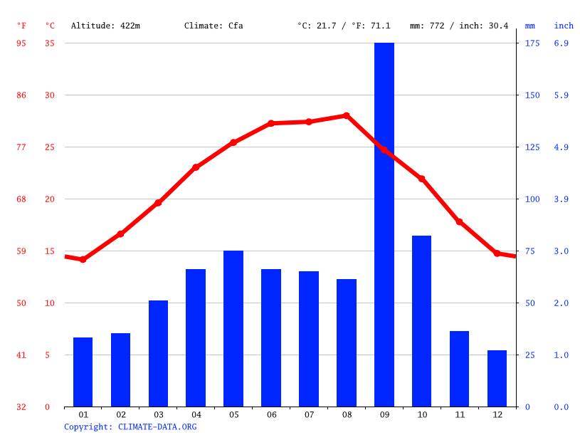
Elevation
790 m (2592 ft)
Climate
This region has a tropical climate. May through October tend to be wet, and December through March tend to be drier. In August, the average high temperature is 31°C (89°F) and the average low is 17°C (63°F).
Chahuites
Chahuites is in the south-eastern side of Mexico. In the area, there are approximately 11,356 people. The population is mostly comprised of young people. The largest industry in Chahuites is producing mangos. Crops grow quite well in this area due to good rainy and dry seasons. Chahuites means ‘wet’. Despite the fertile ground, there is a lot of poverty in this area. Over 90% of the poorest municipalities are in the south of Mexico in the state of Oaxaca. Chahuites is off the beaten trail and many of the inhabitants live quiet lives. Thus, the needs of this area are often overlooked for the larger urban centers. Indigenous Mexicans are closely tied to their communities and rarely leave their municipalities for any reason. Therefore, even though there are two medical units in the urban core, there is a general fear of the unknown, and they will rarely leave their municipality even to seek needed medical care. Those who do are faced with travel and food expenses and usually face several trips for consultations, studies, and lab work. The team will be providing care to the more remote areas in this region.
* Project Description: The MMI team will provide medical, dental and eye care, physiotherapy and audiology, to help the municipality deal with the need for these services, traveling to some of the more remote villages in the region.
Elevation
22m (72 Ft)
Climate
The wet season from May to October is overcast and the dry season November to April is windy and mostly clear. Temperatures year round can vary from 23 C to 35 C.
Comitán, Chiapas
Comitán is the fourth-largest city in the Mexican state of Chiapas. It is the seat of government of the municipality of the same name. It is located in the east-central part of Chiapas, near the Guatemalan border. The municipality has an area of 1,043.30 km² (402.82 sq mi). Its largest other community is the town of Villahermosa Yalumá.
Comitán is also a popular tourist destination, mostly for Mexican nationals, though some foreign visitors can also be seen. The town possesses colonial architecture, narrow avenues, and clean streets. The climate is cool most of the year, and can get quite chilly from October to March.
* Project Description: Projects are held in Pueblo Nuevo Solistahuacán, Chiapas, where we offer Dental, Optical, and Medical services. The MMI teams collaborate with local health authorities to provide cataract surgeries and optometry to help the municipality deal with the need for vision services. We also serve in the surrounding communities in need.
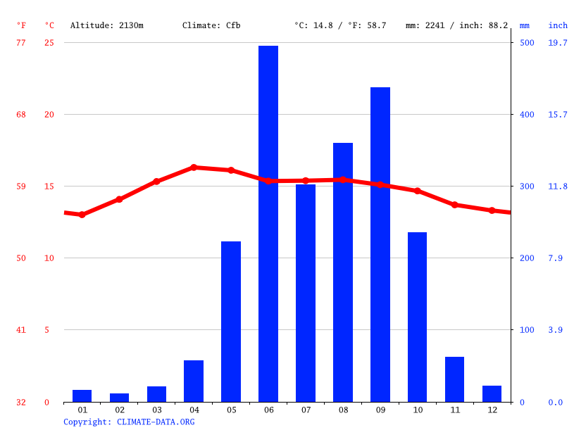
Elevation
1602 m (5256 ft)
Climate
The average temperature is around 24°C (75°F) and average annual rainfall is 890 mm (35 in).
Most rainfall (rainy season) is seen in June, July, August, September and October.
Copainalá, Chiapas
Copainalá is a town in southern Mexico. Chiapas has mountainous highlands and dense rainforest are dotted with Mayan archaeological sites and Spanish colonial towns. Despite being rich in resources, Chiapas lags behind the rest of the country in almost all socioeconomic indicators, including income, education, health and housing. The municipality of Copainala is made up of a number of rural communities about one and a half hours from Tuxtla Gutierrez. Many of the smaller communities have rural health clinics which are set up to basically monitor diabetic and hypertensive patients and pregnancies. They also serve as a point of referral for more specialized services, but are often staffed with only a nurse or a “pasante” (medical student in their final year of medicine doing their year of social service). There is no dental care at all in the communities outside of the main town in each of the municipalities.
* Project Description: The MMI team will provide medical, dental and eye care, physiotherapy and audiology to help the municipality deal with the need for these services, traveling to some of the more remote villages in the region. We expect to see 40-50 medical patients each day, 60 eye patients and 20-30 dental patients MMI will provide medicines for the medical patients, reading glasses for eye patients, dental services of cleaning, extraction and restorative care.
Elevation
4,093 m (13,428 ft)
Climate
This region has a tropical climate. The average annual temperature is 23.9 °C in Copainalá, and rainfall averages 1419 mm.
Dolores-Hidalgo, Guanajuato
Dolores Hidalgo is the name of a city and the surrounding municipality in the north-central part of the Mexican state of Guanajuato. Dolores Hidalgo is known primarily for its ceramics industry, started by Father Hidalgo, which provides income to well over half the city's population. The inexpensive and mass-produced output of the town is marketed throughout Latin America and the United States. The central square of the town, in front of Fr Hidalgo's historic church, is a popular tourist spot.
* Project Description: The need for ophthalmological services in this area continues to increase as levels of poverty rise. Medical Ministry International was asked to perform cataract surgeries in Ocampo and Guanajuato where the government has agreed to provide facilities in the public hospital. Patients will be screened by the graduate doctors working at a center in Mexico, and the Medical Ministry International team will perform surgery to patients previously screened. The goal is to provide 150 surgical cases per week. The Integrated Health component includes discussion about eye care, hygiene, preventing the spread of germs, dental health, and information about the clinic stations.
Elevation
1,980 m (6,480 ft)
Climate
Dolores Hidalgo is influenced by the local steppe climate with an average temperature of 18°C. There is little rainfall throughout the year, averaging annually at 538 mm.
Montemorelos
Montemorelos is a city and surrounding municipality of 53,854 inhabitants. It is located in the Northern Mexican state of Nuevo León, in the valley of the Pilon River. It was named after its founder.
Montemorelos is considered as the orchard of the State of Nuevo León for its fertile lands and growth of fruits and grains. Due to its quality of its citruses, the city of Montemorelos is called the Orange Capital. In addition, it also cultivates grapefruits, tangerines, sorghum, maize, gleans, and beans.
* Project Description: The projects take place at a vision institute in Montemorelos. The team will perform cataract surgery and provide eye care. The Integrated Health component includes discussion about eye care, hygiene, preventing the spread of germs, dental health, and information about the clinic stations.
Elevation
407 m (1,338 ft.)
Climate
Humid and cold with an average high of 22°C (71.6°F) and low around 7°C (44°F).
June - High 34°C (94°F), Low 22°C (71°F).
San Cristóbal de las Casas, Chiapas
San Cristóbal de las Casas is a town and municipality located in the Central Highlands region of the Mexican state of Chiapas. It was the capital of the state until 1892, and is still considered the cultural capital of Chiapas.
The municipality is mostly made up of mountainous terrain, but the city sits in a small valley surrounded by hills. The city center maintains its Spanish colonial layout and much of its architecture with red tile roofs, cobblestone streets, and wrought iron balconies often laiden with flowers. Most of the city’s economy is based on commerce, services, and tourism. Tourism is based on the city’s history, culture, and indigenous population.
Major landmarks of the city include the Cathedral, the Santo Domingo church with its large open air crafts market, and the Casa Na Bolom museum. The municipality also has natural attractions such as caves and rivers.
* Project Description: The MMI teams collaborate with local health authorities to provide cataract surgeries and optometry to help the municipality deal with the need for vision services. We are based in the city of San Cristibal, a central hub for many communities living with poverty.
Elevation
2,134 m (7,001 ft.)
Climate
The average temperature for June is a high of 22°C (72°F) and a low of 14°C (57°F).
Tonalá, Chiapas
The municipality of Tonalá is made up of several rural communities in the coastal region in the northwestern corner of the state of Chiapas, on the Pacific Ocean. Despite being rich in resources, Chiapas lags behind the rest of the country in almost all socioeconomic indicators, including income, education, health, and housing. The inhabitants of these municipalities are mainly country people with small subsistence farms, or fishermen. Some sell minimal amounts of produce but most live off government-sponsored and community programs. Most live in small houses, some without indoor bathrooms, and most cook on outside wood fires rather than in kitchens.
Many of the smaller communities have rural health clinics which are set up to basically monitor diabetic and hypertensive patients, and pregnancies. They also serve as a point of referral for more specialized services but are often staffed with only a nurse or a “pasante” (medical student in their final year of medicine doing their year of social service). There is no dental care at all in the communities outside of the main town in each of the municipalities.
* Project Description: The MMI team will provide medical, dental, and eye care, and physiotherapy and audiology, to help the municipality deal with the need for these services, traveling to some of the more remote villages in the region.
Elevation
60 m (200 ft)
Climate
This region has a tropical climate. May through October tend to be wet, and December through March tend to be drier. In August, the average high temperature is 31°C (89°F) and the average low is 17°C (63°F).
Tuxtla Gutiérrez, Chiapas
Tuxtla Gutiérrez is the capital and the largest city of the Mexican southeastern state of Chiapas. It is a busy government, commercial, and services-oriented city, with a population of just over 600,000.
Chiapas has mountainous highlands and dense rainforest are dotted with Mayan archaeological sites and Spanish colonial towns. Despite being rich in resources, Chiapas falls behind the rest of the country in almost all socioeconomic indicators, including income, education, health, and housing. Tuxtla Gutiérrez is central to a number of rural communities in the Chiapan highlands, lowlands, and coast. Many of these communities have rural health clinics which are mainly set up to monitor pregnancies, diabetic patients, and hypertensive patients. They often also serve as a point of referral for further specialized services but have limited staff and resources. These communities have no local access to dental care. Rural Mexican's rarely leave their municipality; even to seek needed medical care. Those who do are faced with high travel and food expenses and will likely be required to make a number of trips for consults, studies, and lab work.
* Project Description:On these projects, Mexican and North American volunteers provide needed medical services for 1 or 2 weeks in Tuxtla Gutiérrez and surrounding communities in collaboration with local municipal and health authorities. The Vision Projects provide cataract surgeries, optometry services, and glasses to help the municipality deal with the need for vision care.
Elevation
522 m (1712 ft)
Climate
Tuxtla has a tropical wet and dry climate. Except for a rainy and dry season (summer-fall and winter-spring respectively) there is little variation in the climate during the year.


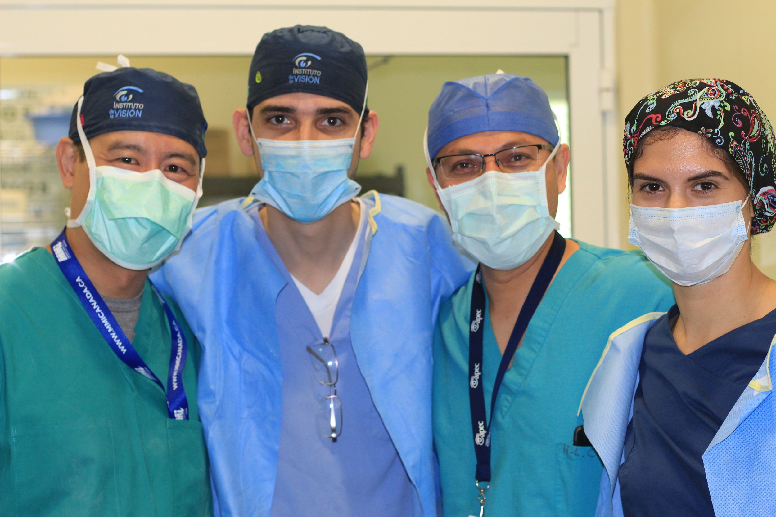
MONTEMORELOS, MEXICO SUPPORT TEAM
Travelling on a Project

About Mexico
COUNTRY BACKGROUND
Mexico, officially called the United Mexican States, is a federal republic in the southern portion of North America. Many years ago, the Aztecs were a highly developed, rich Mexican civilization. Their elegant capital city, Tenochtitlan, may have been the largest city in the world in the early 1500s. In 1519, the Spanish explorer Hernando Cortes landed in Mexico. He was amazed by the Aztec civilization and its gold. The Aztecs welcomed these pale visitors as gods, but the Spanish were more interested in the Aztecs' wealth. After two years of struggles, Spanish fighters captured Tenochtitlan and burned it to the ground. Then they built Mexico City on its ruins. Today, Mexico City is one of the largest cities in the world. Mexico remained under Spanish control until a long struggle ended in Mexico's declaration of independence in 1821. Due to its rich culture and history, Mexico ranks first in the Americas and seventh in the world by number of UNESCO World Heritage Sites. Mexico is a megadiverse country, ranking fourth in the world by biodiversity. In 2016 it was the eighth most visited country in the world, with 35 million international arrivals.
Most of Mexico's people today are "mestizos" — a cultural identity used by people who have both Indigenous and Spanish ancestors. About 90% of Mexicans are Roman Catholic. Mexico has many beautiful churches and shrines, and people mark special days with colorful religious festivals. Mexico has a strong culture and traditions, and its people have worked to make its democracy stronger. There are many people living in poverty in Mexico, as well as many who are middle-class. Many people have left the harsh poverty of Mexico's countryside to move into its crowded cities.
LOCATION:
North America, bordering the Caribbean Sea and the Gulf of Mexico, between Belize and the United States and bordering the North Pacific Ocean, between Guatemala and the United States.
GEOGRAPHIC COORDINATES:
23 00 N, 102 00 W
MAP REFERENCES:
North America
TOTAL AREA:
1.964 million km²
BORDER COUNTRIES:
Belize, Guatemala, US
COASTLINE:
9,330 km
MARITIME CLAIMS:
12 nautical miles
CLIMATE:
Tropical along coast and eastern plains; cooler in highlands
TERRAIN:
High, rugged mountains; low coastal plains; high plateaus; desert
ELEVATION EXTREMES
LOWEST POINT:
Laguna Salada - 10 m
HIGHEST POINT:
Volcan Pico de Orizaba - 5,675 m
